The majority of the fieldwork at the Nobles Pond site consisted of two activities:
- Excavation
- Surface collection
Excavation
Excavation started in 1986 and continued through April 15, 1996. Thousands of volunteers (the Nobles Pond FORCE) helped dig and screen a total of 5,865 square meters during those years.
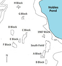
There were ten major excavation blocks, several minor blocks, and numerous isolated test meters. The major excavation blocks were as follows:
- 1987 block
- South Field
- A block through H block
More about our excavation blocks
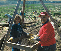
For each meter excavated, a tripod crew shoveled the topsoil into a hanging screen and sifted the dirt through 1/4-inch metal mesh. Objects larger than 1/4 inch (gravel, chert flakes, stone tools) stayed in the screen after sifting out the dirt.
After the topsoil was removed, the subsoil (a continuous clay layer) was scraped flat and checked for features such as postholes and fire pits. If we found a feature, we investigated it using more precise techniques, such as sectioning or removing the dirt fill with a trowel.
Surface Collection
The field containing the Nobles Pond site was plowed and disked several times each year to facilitate surface collection. Thousands of artifacts were recovered from the site through surface collection.
Surface collection provided an alternate, less labor-intensive means of gathering useful information. It helped to identify areas that might be worth excavating. During the core years of fieldwork, the locations of surface finds were marked by small flags. A field crew later measured in the flags, and the locations were marked on a site map. The map provided a visual guide to areas with significant artifact density.


